Product
Surveying & Mapping Software
Enhance your projects with cutting-edge technology
Controllers & Tablets
Highlights
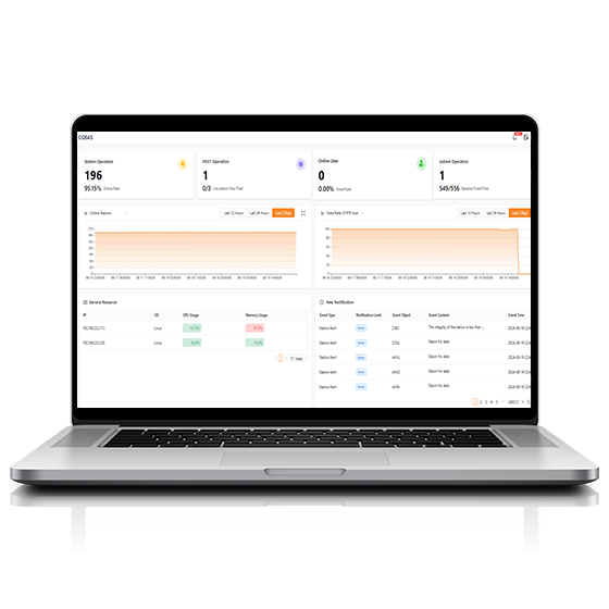
The CGBAS platform is a comprehensive, server-based solution designed to manage and operate GNSS CORS and RTK networks on a regional or nationwide scale. Utilizing advanced algorithms, CGBAS establishes models to solve ionospheric delay, tropospheric delay, orbit errors, and more, ensuring high-quality and reliable RTK corrections. With support for protocols like direct TCP/IP and NTRIP, along with user management features, CGBAS delivers dependable GNSS corrections for a wide range of applications.

Key Features
A durable and high-performance device designed for precision and efficiency.
Full GNSS
Supports GPS, GLONASS, Galileo, BeiDou, and QZSS.
24/7 Operation
Manage over 5,000 reference stations and 100,000+ concurrent users.
Turnkey Platform
Station management, data processing, correction broadcasting, user management, coordinate systems, and more.
Performances
Product Features and Highlights
GNSS Positioning Services
CGBAS integrates GPS, GLONASS, Galileo, BeiDou, and QZSS to deliver GNSS RTK positioning services. Supporting the new generation of BeiDou signals for enhanced accuracy, it integrates with various GNSS receiver models, making it a versatile solution for any GNSS infrastructures.
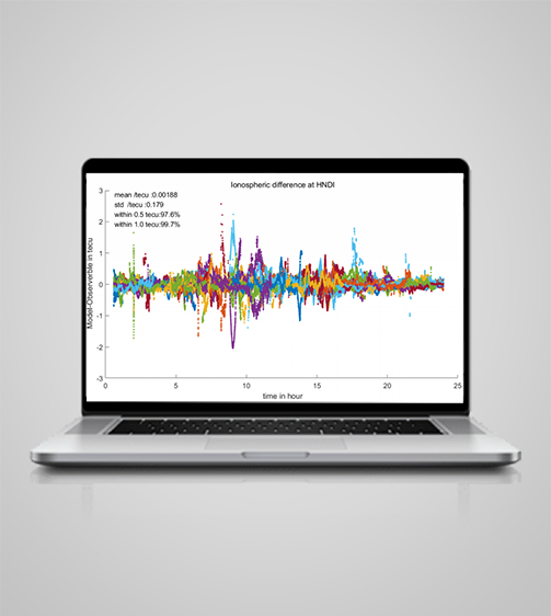
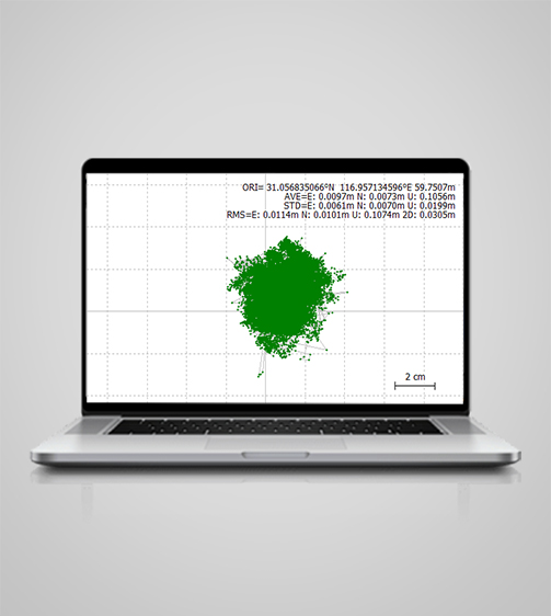
Real-Time Accuracy Control
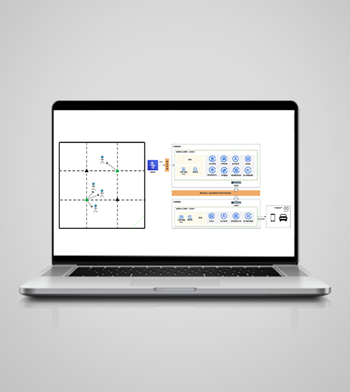
CGBAS employs advanced algorithms for ionospheric and tropospheric delay modeling, trained on extensive observation data. Real-time monitoring of data quality, baseline processing, ambiguity resolution in triangulated baseline networks, and ionospheric interpolation contribute to reliable GNSS RTK correction services.
Features-rich for Easy Deployment
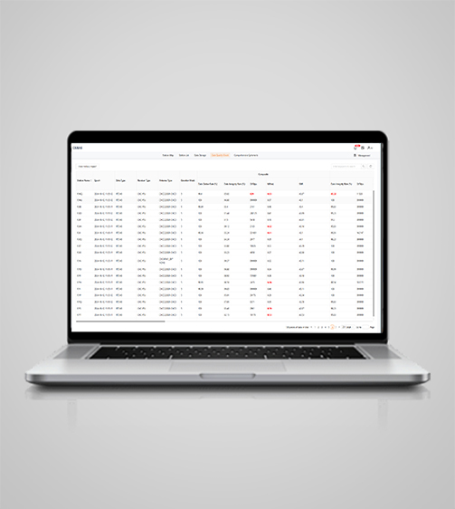
CGBAS includes modules for station management, data processing, correction broadcasting, user management, coordinate systems, and online maps. It also offers post-processing capabilities through access to Rinex and a virtual Rinex engine.
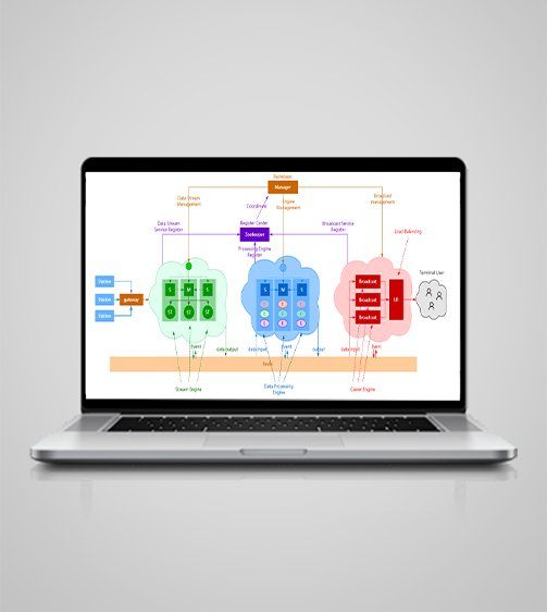
Scalable Network Management
CGBAS supports distributed and single-machine deployment, allowing users to select the optimal solution based on the number of base stations and terminal connections. Horizontal scaling ensures the system can expand to higher specifications without interrupting operations.
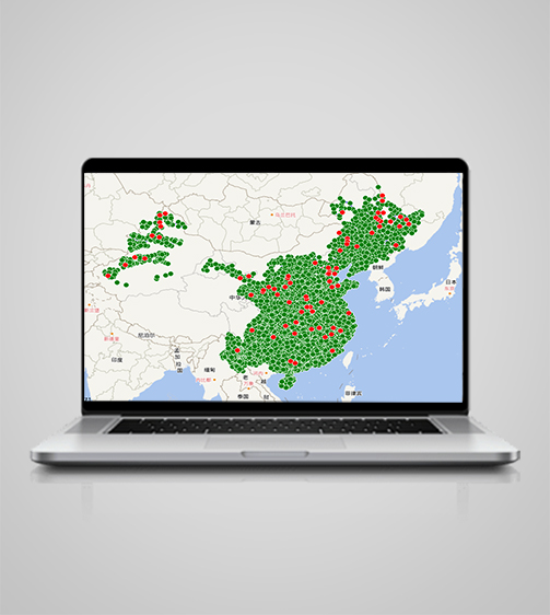
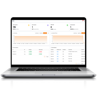
High-Concurrency 24/7 Operation
With backup and load-balancing capabilities, CGBAS achieves up to 99.9% availability. Redundant, off-site dual backups, node self-healing, and automatic failover minimize the impact of server node failures. The microservices architecture enables management of over 5,000 stations and 100,000+ concurrent users.
A Security-Focused Platform
CGBAS prioritizes data and network security by isolating internal and public networks and utilizing custom compression formats for one-way data transmission. To further protect against base station coordinate leakage, it offers coordinate offset functionality.
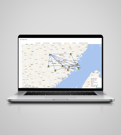
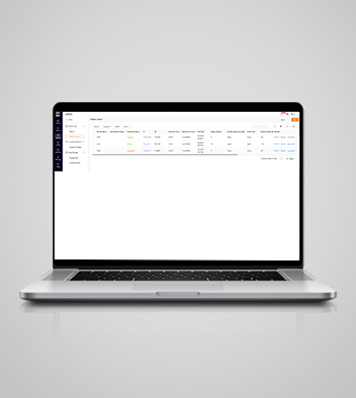
Real-Time Services Monitoring
An online map and visual statistics enable continuous monitoring of data quality at both base stations and terminal endpoints. Alarms provide prompt notifications, improving operational timeliness and reducing pressure.
End-to-End Positioning Performance
CHCNAV integrates auxiliary functions between the P5 station, CGBAS, and CHCNAV terminals. It broadcasts auxiliary positioning data to enhance terminal accuracy. It also supports batch receiver restarts, upgrades, and configurations, even when base stations lack public IPs.
Use Cases
Applications of the CGBAS
GNSS RTK Networks
Utilize precise GNSS networks for real-time kinematic positioning.
Precision Agriculture
Enhance farming techniques with precise location-based data for optimal results.
Topographic Surveying
Survey and map terrain with high-accuracy GNSS measurements.
Detailed Specifications
Product Details
-
System
Operating System: Linux, Windows Server, Kylin
Languages: English, Chinese, Customizable -
Features
Functions: Web-based GNSS RTK augmentation services
Modules: Stations, Subscriptions, Processing -
Connectivity
Device: Bluetooth, Wi-Fi
Cloud: Data storage and remote support -
Interface
User menu: Customizable
Online basemaps: Google, Bing, WMS, WFS
Seeking a Perfect Solution to Fit Your Needs?
Contact G-Surv Corp to create a customized precision solution tailored to meet the specific needs of your business. Let's get in touch and discuss how we can assist you.
Our Clients
Trusted by Leading Companies


 G-Surv Corp
Address
40 Visayas Ave, Diliman, Quezon City, Metro Manila
Call Us
+63 927 929 1674 |+63 968 860 9025
Email Us
gsurvcorp@gmail.com